
BlueChart g3 microSD with SD Adaptor - Yellow Sea

BlueChart g3 microSD with SD Adaptor - Yellow Sea
Our Advanced Chart Offering
- Derived from official charts and private sources to provide navigational aids, spot soundings, depth contours, tides and currents, and detailed harbors and marinas
- Depth Range Shading for up to 10 depth ranges enables you to view your target depth at a glance
- Up to 1-foot contours provide a more accurate depiction of the bottom structure for improved fishing charts and navigation in swamps, canals and marinas
- Shallow Water Shading feature allows for depth shading at a user-defined level to aid in navigation
- Worldwide coverage available
- Keep your charts up to date with our industry-leading New Chart Guarantee and discount card update program
See More of Your Surroundings
See your surroundings more clearly with BlueChart® g2 data. With BlueChart g2, you’ll get detailed marine cartography that provides convenient viewing of nautical content. BlueChart g2 allows you to see your vessel's precise, on-chart position in relation to naviads, coastal features, anchorages, obstructions, waterways, restricted areas and more. You will also have access to detailed mapping capabilities that include Safety Shading¹, Fishing Charts¹, smooth data transition between zoom levels, harmonious transition across chart borders, and reduction of chart discontinuities.
Click the Products tab to see if this map is compatible with your Garmin device.
¹in compatible units
The microSD or GarminCard may be programmed on a recycled card.
Comparison:
BlueChart Feature Comparison
|
Feature |
BlueChart g3 Vision | BlueChart g3 |
|---|---|---|
| Integrated Garmin and Navionics content | • | • |
| Auto Guidance¹ technology | • | • |
| Depth range shading | • | • |
| Up to 1' contours | • | • |
| Shallow water shading | • | • |
| Raster cartography² | • | • |
| High-resolution relief shading | • | |
| Unique 3-D views | • | |
| High-resolution satellite imagery | • | |
| Aerial photos | • |
¹Auto Guidance is for planning purposes only and does not replace safe navigation operations
²Raster cartography is available for selected countries. It cannot be viewed on echoMAP CHIRP and ECHOMAP Plus combos but can be viewed on mobile devices via the ActiveCaptain mobile app
Requirements:
Download Requirements
File Information
The file size of this download and space required on your microSD™/SD™ card is 481.38 MB. It is not recommended that this download be loaded directly to your device. It only can be loaded to a prepared or blank microSD/SD card (recycled microSD cards may be used to program map data).
Up to 500 MB of additional space may be required for software updates.
microSD™/SD™ Requirements
Features:
- Realistic navigation features showing everything from shaded depth contours and coastlines to spot soundings, navaids, port plans, wrecks, obstructions, intertidal zones, restricted areas, IALA symbols and more.
- Smooth display presentation including seamless transitioning between zoom levels and more continuity across chart boundaries.
- Safety shading allows user to enable contour shading for all depth contours shallower than user-defined safe depth.
- Fishing charts to help scope out bottom contours and depth soundings with less visual clutter on the display.
- Choice of standard 2-D direct overhead or 3-D "over the bow" map perspective to make chart reading and orientation easier.
- Compatible with HomePort™ — software that lets you use BlueChart data to conveniently plan and organize routes from your computer before your trip.
Coverage:
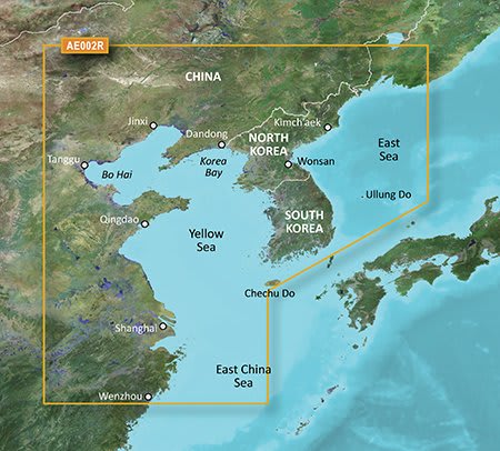
General coverage of the Chinese coast from Wenzhou to Dandong; the South Korean coast in its entirety; the full west coast of North Korea and the east coast south of Kimch'aek. Included in this overall general coverage are numerous detailed charts covering areas in China such as Shanghai, Qingdao, and Dalian; and also Nampo, N.Kor., and Pusan, S. Kor.